


Monsoon Days in Dinagat Island
Last February I spent two weeks going around Dinagat Island, doing recon in preparation for a research project focused on the island's unique mammals.

It’s late February during the Northeast Monsoon, and over the rough terrain of Dinagat Island comes the drenching shadow of the Pacific Ocean. Low clouds roll in from the glassy sea, scraping their bottoms against fog-shrouded peaks; the spill falls over forests and farms and great yawning mining pits. Ever since we arrived a few days ago, the weather has all been downpours and spraying wind, everything hidden behind a curtain of dense showers.
We’re here to do some recon. ‘We’ meaning my boss and the rest of the project team, looking for ideal places to set up rat traps and camouflaged cameras. Dinagat lies flung along the eastern edge of the Philippines, just a short distance away from the larger landmass of Mindanao. With its relative isolation come surviving pockets of unique mammal fauna in dire need of study, hence our visit. We’re not about to do any sampling just yet; for now we just want to map out promising areas where we can camp and do our research.
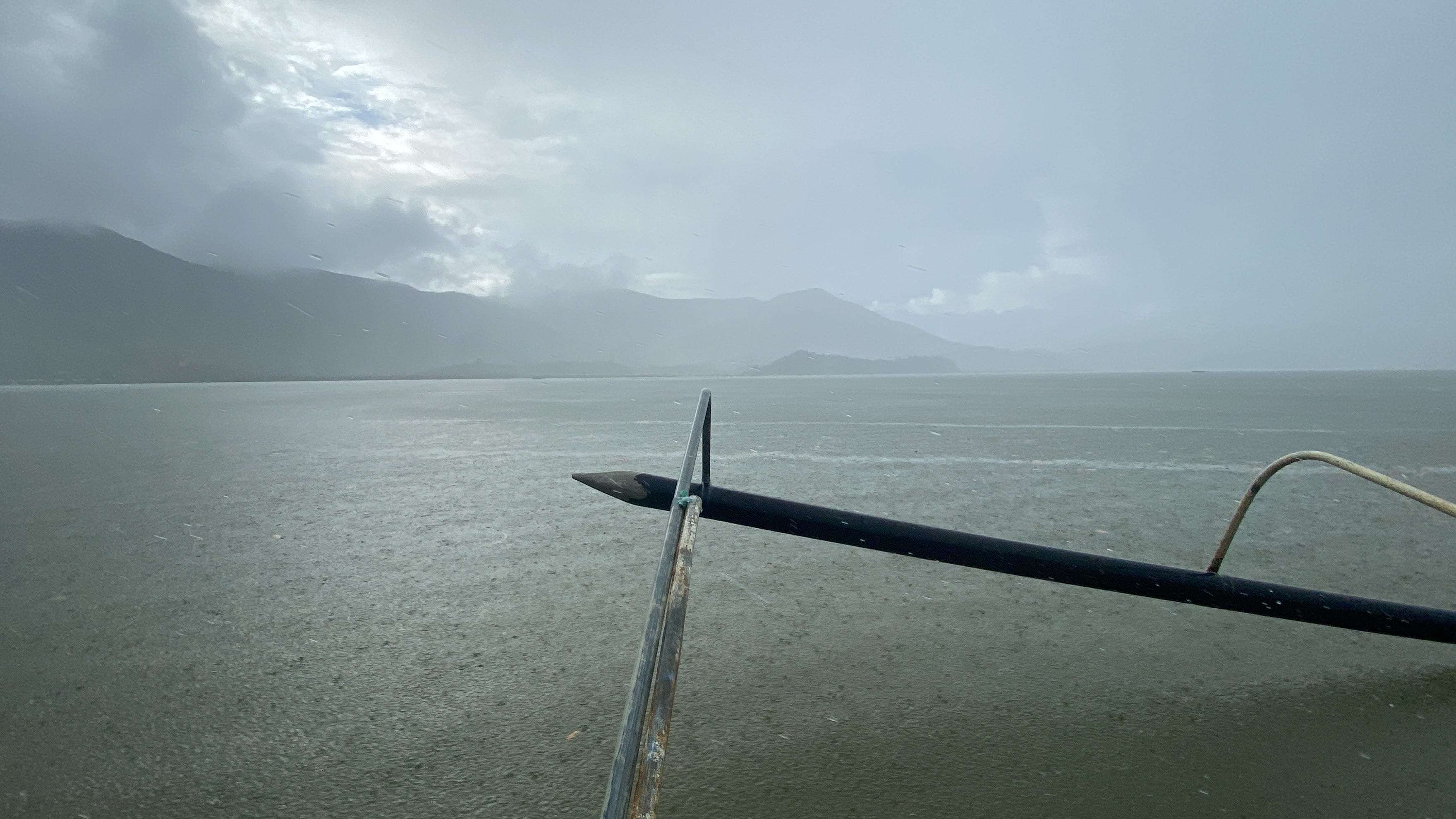
But with the foreboding skies, it’s been difficult to arrange a tour of the surrounding jungles. There’s the risk of landslides and flash floods, not to mention the slippery trails and the mud. Several of the places we had planned to visit require an initial voyage by boat to the base of misty green slopes. Good luck with that, people said. If you think overland travel is bad, try riding the chop of a sodden grey sea.
With long hikes inadvisable, we’ve been using our time to stop by local government offices around the island, meeting with environmental staff, securing study permits, and the like. So far everyone has been very helpful. So far everyone has also been saying the same thing: alas, the weather.
“The rain is really strong here,” says the administrative officer in her air-conditioned office at the municipality of Basilisa. Echoing in the background comes what sounds like a thousand tiny hands playing a steady drumbeat on the roof. “You’ll have a hard time going around. It might take a while before the weather improves, though,” she says.
She explains that the heaviest floods used to fall from October to December. That’s what my boss remembered too, having been in the area before. It’s why the team had planned our recon visit for late February, precisely to avoid the rain.
“To tell the truth,” says the administrative officer, “it hasn’t always been this way.” Why have the skies changed? I ask her. “Probably climate change,” she replies with a shrug, before reassuring us about the pending approval of our permits.
Sheets of water continue to fall outside. As we stand up to leave, the officer tentatively shares a promising sentiment. “It’s good to study wildlife,” she says. “People here tend to think that all rodents are pests. But that’s not true. After all, who knew that there could be so many types of rats in the Philippines?”
From the satellite’s eye view of Google Earth, Dinagat with its population of over a hundred thousand people resembles a shard of jade, the dark green of its surface interrupted by raw brown speckles and snaking fissures. Zooming closer you can see towns, roads, small farming and fishing villages. The bald spots on the mountains resolve into quarries and man-made barrens, the largest of these crude holes resembling Martian calderas hacked recklessly into the earth.
In 1939, President Manuel L. Quezon issued Proclamation No. 391, declaring the entirety of Dinagat a strategically important mining reservation. If you look at a map prepared by the Mines and Geosciences Bureau of the Department of Environment and Natural Resources, you can see that most of the island has been shaded neon red. These great swathes of color, bright as blood, represent various parcels of land covered by a Mineral Production Sharing Agreement, or MPSA. A company with an MPSA enjoys exclusive mining rights within its designated area. In other words, over half the island falls under some kind of mining claim.

Why all this furious commercial interest? To understand, we must begin with the ancient past. Ages ago, tectonic forces pushed slabs of ancient oceanic crust up out of the waves and into the light of day. Such sizeable outcrops of ophiolites, as these layers of uplifted marine rocks are called, are relatively rare, and the ores they contain are prized for their use in manufacturing everything from steel ingots to the batteries of solar panels.
Conversely, however, the same geological oddities that continue to make the place so lucrative for mineral exploration also make it host to spectacular biodiversity. Over the millennia, as wind and water work their erosive powers, ophiolites crumble into what is known as ultramafic soil, a substrate noted for its high concentrations of heavy metals and scarcity of important nutrients like nitrogen and potassium. You know when you’re in the presence of these hot, dry soils because of the persistent ochre stain that will appear on your clothes. The reddish color comes from all the iron in the dirt.
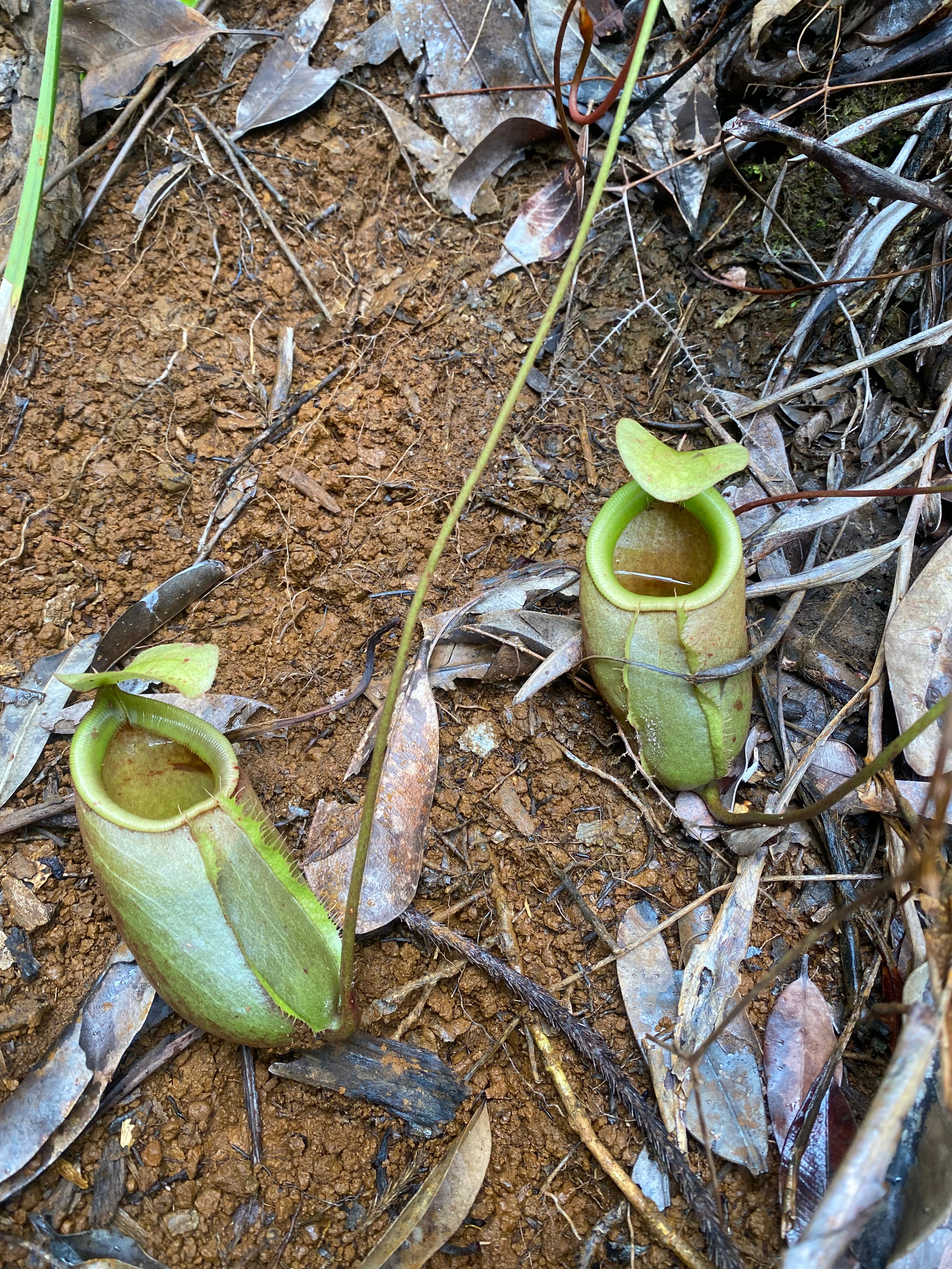
For plants, ultramafic soils are extreme environments. There is little water, scant shelter from the heat of the sun, and the clay on which their roots depend exude deadly metal toxins. And yet, many flora have found a way to survive, even thrive in such harsh surroundings. Forced to adapt to such peculiarly difficult conditions, the result has been flourishing uniqueness; many of the pitcher plants, magnolias, rattans, palms, and other kinds of plants that inhabit Dinagat can be found nowhere else on the planet.
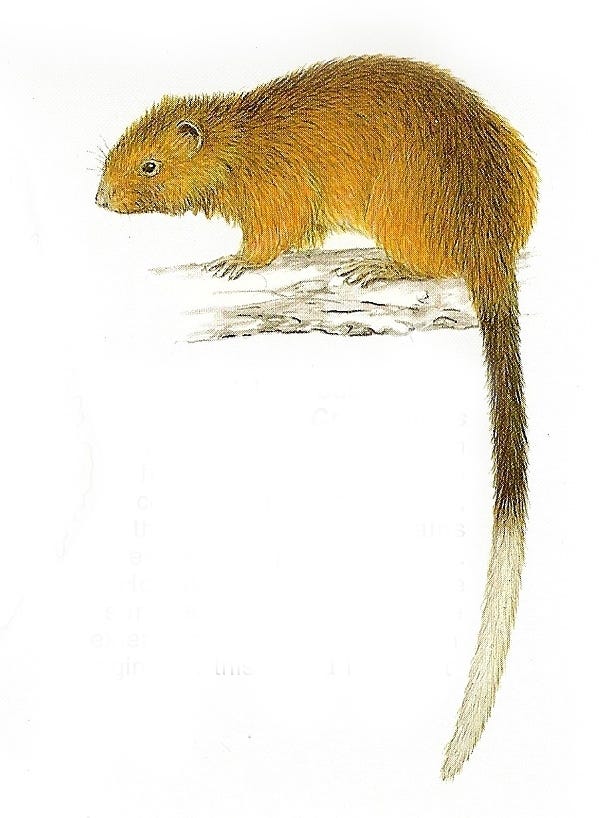
The same goes for the animals. Three species of small mammals can be in the island and only on the island: the Dinagat gymnure, Podogymnura aureospinula; the Dinagat hairy-tailed rat, Batomys russatus, and the Dinagat cloud rat, Crateromys australis.
Scientists once feared that C. australis, a furry creature with a long tail capped by a white tip, first described in 1985 then hardly seen since, had perhaps gone extinct. Then, last 2012, a team of researchers caught the rodent on video scampering on a tree. More recently, in 2023, the Dinagat cloud rat was again photographed in a mountain resort in the municipality of Basilisa.
The increased number of sightings is encouraging. But even with the spike in documented observations, plenty of questions about C. australis remain. What trees do they like to sleep in? How far away do they travel to find food? What time of the year do they mate, and how long does it take for them to give birth? These and many other basic facts about C. australis and its peers remain frustratingly, tantalizingly unknown.
February passes into March, and as the days ease by so too does the rain. Storms fade to light showers, showers to drizzles. And while the overcast skies never really do disappear, on those rare mornings where the sun manages to peek through the clouds, you can catch the sea flashing in the distance, Brahminy kites riding high above the waves.
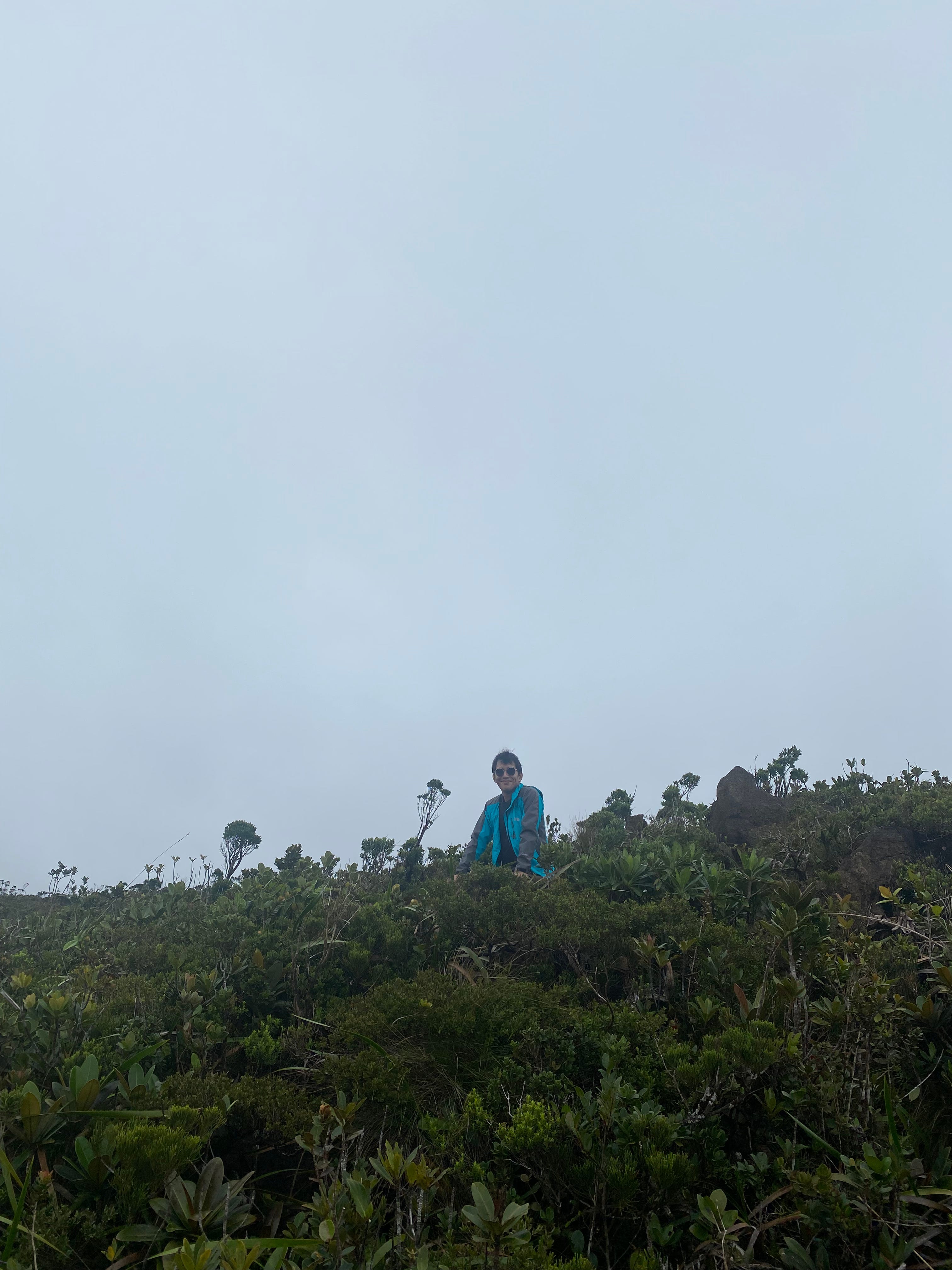
The weekend finds us crammed into a hired pickup heading for the top of Mt. Redondo, Dinagat’s tallest mountain. The drive begins in the lowlands of Loreto. You take the highway out of town, speeding along until a checkpoint, where the guard will be expecting a pass from the municipal tourism office. That done, it's only a short distance to a rusted nondescript gate. Everything beyond that threshold - the dirt, the gnarled trees, the tendrils of mist groping blindly down shattered and carved-out slopes - belongs to Krominco, Inc.
The company, which first won a contract to exploit the chromite deposits in Mt. Redondo last 1977, halted work last 2017, a casualty of the late DENR secretary Gina Lopez's crusade against mining operations. As a result, few vehicles now travel the rough unpaved road up to the mine, and the climb feels surprisingly eerie. It's just you and the crunch of rocks trod underfoot by the wheels. Each additional meter of elevation brings you deeper and deeper into the banks of fog shrouding the obscured peak. layers of damp vegetation drooping silently on either side.
It feels like a sequence from Jurassic Park. It’s positively primeval. And then you keep climbing and climbing until you come to a breach in the clouds, and all resemblance to the world of dinosaurs falls away.
Visitors aren't allowed to take pictures of the company's mining pit, and it's easy to understand why. With the drills shut down and the trucks sent home, the dig looks like an explosion frozen in time. The naked flayed soil, the heaps of boulders scattered all around like so many discarded knucklebones. It’s stunning, stupendous desolation. No matter how you spin it, such violence will always be a bad look.
Farther along we come to a compound - several warehouses and what looks like a rusted mill, dilapidated from increasing years of disuse - and sign our names into a logbook. To Krominco's credit, we're not the first biologists to have passed through the area. According to Kuya A., our driver, previous research teams had camped within the compound to access the water and occasional electricity there. And just recently, students from a nearby state university had gone on a field trip up the mountain using the same route we’re using. Because in an irony of ironies, Krominco also owns the only accessible road leading to Mt. Redondo's famous Bonsai Forest.
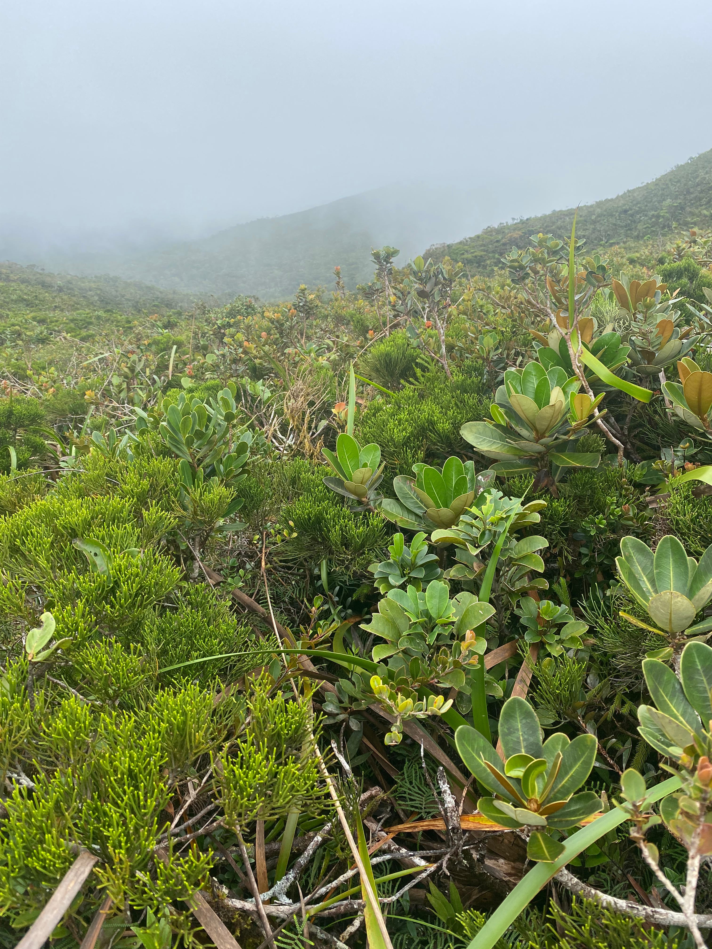
Past the ruined cliffs destroyed by miner’s picks, a diminutive landscape spreads until it disappears beyond a foggy horizon. Pretty little dwarf agohos, neat miniature palms, furtive pitcher plants springing forth as common as weeds. The soil is so nutrient poor, and the conditions so severe, that the trees have adapted by becoming literally hobbit-sized, many growing to at most chest height, if not down to the level of your knees. Much of the forest’s inner workings remain a mystery; new species are being discovered within its fey shadows to this day. Tristianopsis flexuosa, a pale and wizened tree, and Vaccinium coarctatum, a blueberry, all formally described by researchers only during this past decade, and all so far bound to the confines of this singular summit.
I tried to imagine how the place would look like if it were taken care of like the National Parks in the United States, with part of the already levelled slopes perhaps converted to become a welcoming center for visitors, and trails carefully laid out for hikers. Because it’s a gorgeous place, a beautiful place, entrancing enough to get lost in.
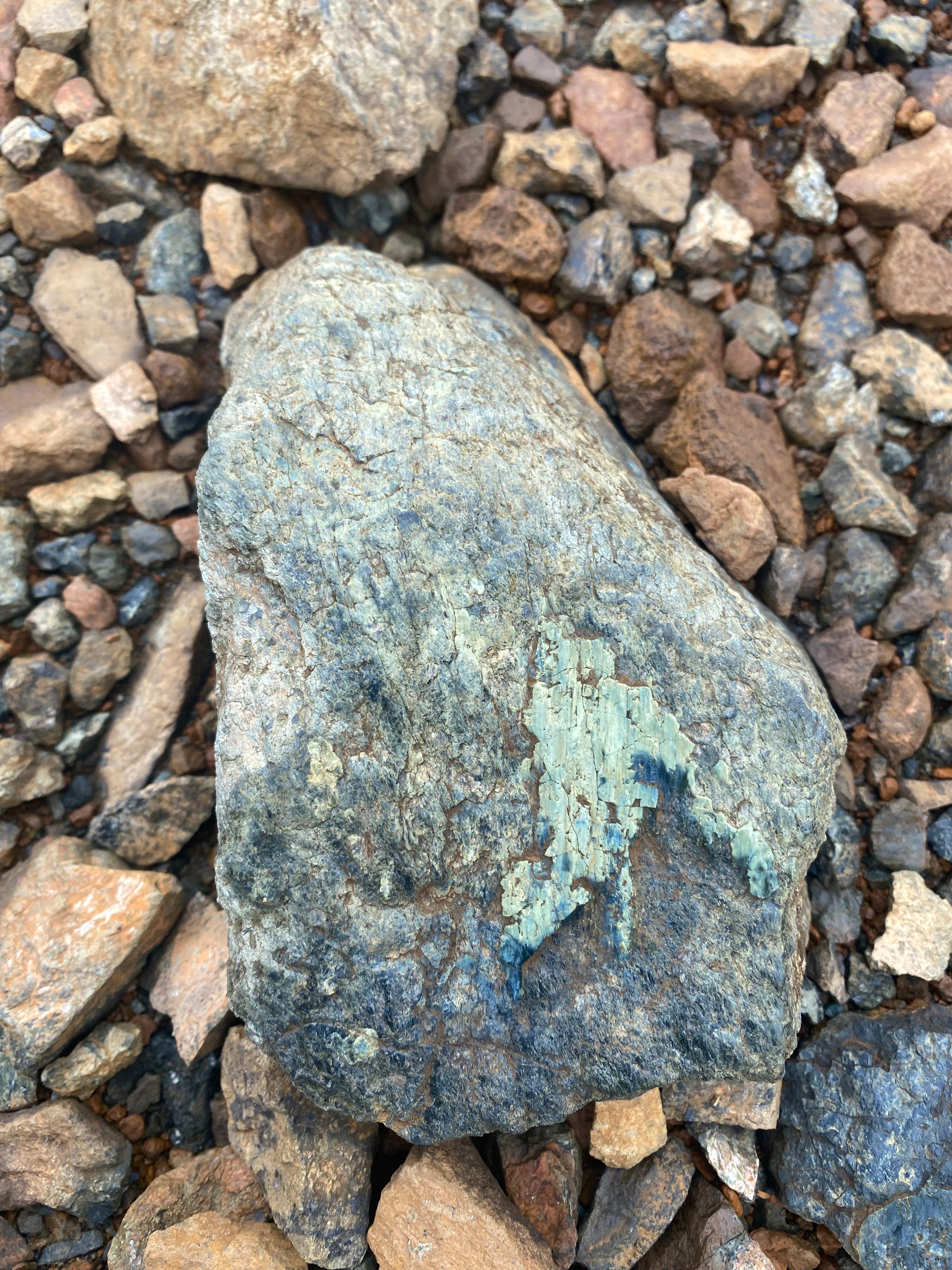
As we follow the looping trail back to our starting point, I notice a stone gleaming on the trail by my feet. It’s a piece of ore perhaps, maybe a slab of chromite, or else nickel, I don’t have the background to know, but you don’t need training to appreciate the meteorite luster of its surface. I crouch down to wipe off some of the dirt and it’s even brighter than before. Turn the stone one side and it shines pale green; turn the other side and it glows a cool platinum. And for a moment, just for a moment, a tiny part of me deep inside begins to understand why people tunnel for gold in the wounded earth.
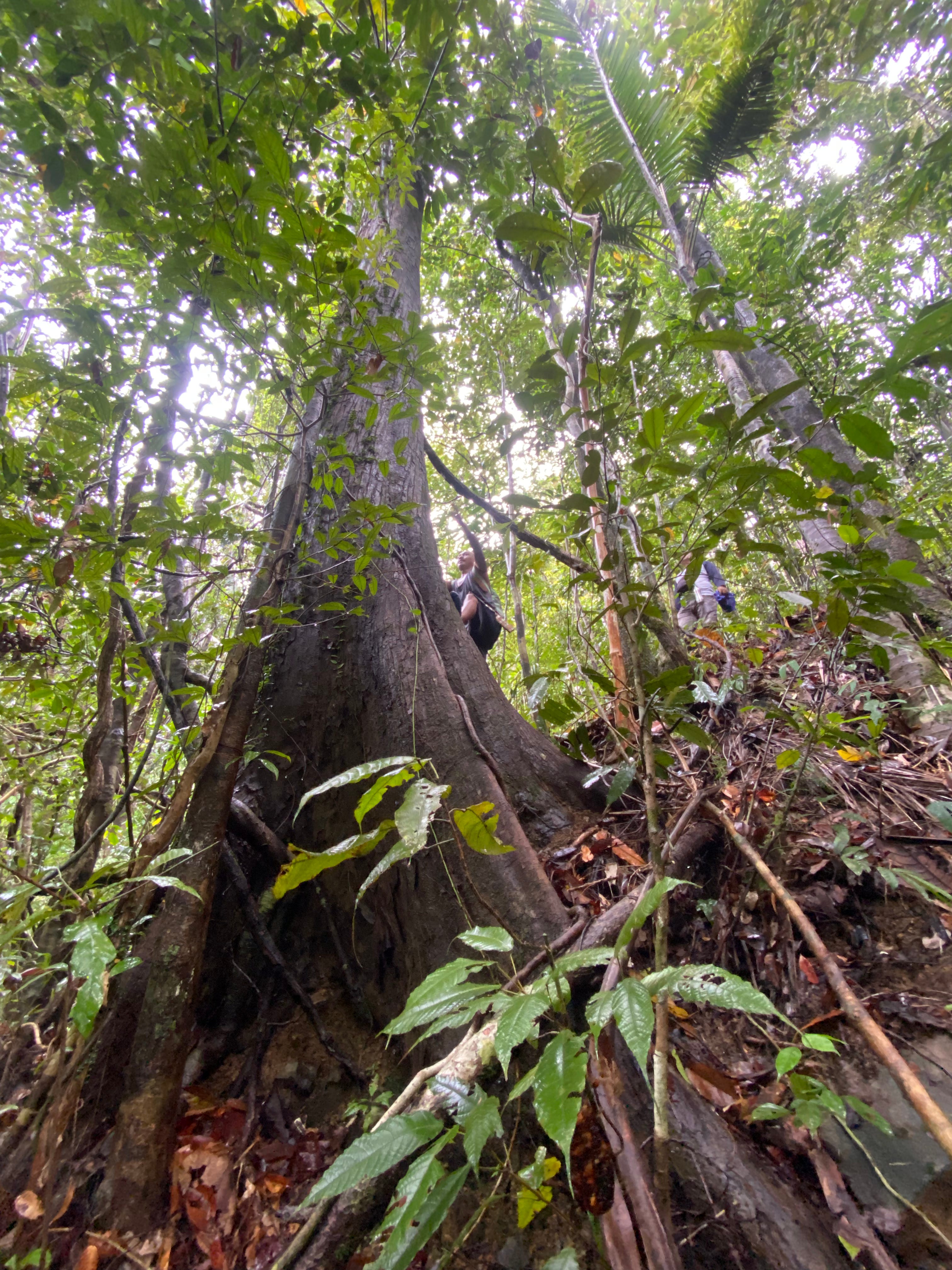
It's a dim afternoon on the empty highway. Earlier we had embarked on what was supposed to be a brief foray into the Paragua Forest to check out its towering dipterocarps. The local guides were quite proud of the forest because it was part of their watershed. In fact, most of the people we met during our trip seemed proud of their watersheds. This is where our water comes from, the water we drink, where the trees stop landslides from happening. Maybe not everyone in the island thinks the same – there are still plenty of denuded slopes, after all – but enough do.
We were around an hour into our hike and about to go back using the same way we came, when one of our guides proposed taking an alternative route instead. We’d see more of the forest compared to just turning around, they said. After all, the purpose of our visit was supposed to be recon, right? Reasonable enough, I thought.
Of course, I probably should have explained to our guides that their clients don’t jog as often as they should. After an additional hour of sweaty trekking, I asked how far we were from the exit. Three more hours, they said. I stared at them blankly. What? Three more hours. And no point turning around since we were already close to halfway through.
“Yeah, you spent a really long time inside there,” says Kuya A., who’s still driving us around on his pickup. He had met us on the highway after we emerged from the foliage, having spent the entire morning on foot. “You took so long I had to eat lunch by myself!”
Right now we’re on the long drive back to our home base further north in the municipality of Tubajon. Above us storm clouds gather and burst. We pass by a small group of kids splashing around the pools forming on the wet concrete. Kuya A. smiles looking at them. He’s remembering his own childhood. “There wasn’t a road here before. Just a rough stony trail. When they finally paved it over the kids were so happy because then the water took longer to drain away, and they could play in the puddles.”
They would play happily into the night, well after dark. And it could get quite dark. “My hometown didn’t have electricity until 2004. When I was a student we knew which families were rich because they would have Petromax gas lamps. The rest of us answered our homework by candlelight.” He laughs. “Not anymore, though. Now you can tell the rich families apart because they have Starlink.”
Stable internet has made life in the province feel less isolated, but Dinagat still suffered greatly during the COVID-19 pandemic. It was one of the last places the virus managed to sneak into, but by the same token it also had a difficult time securing vaccines. “Some people didn’t trust the injections,” says Kuya A. “They were afraid whatever the syringes contained would kill them.”
Does he want to live in the city? No, not at all. “I went to Metro Manila once. I had to call my uncle to drive me home one night because I took the wrong jeepney. And there’s no good fish. Everything’s frozen. The only fresh seafood is Tilapia. I remember we ate fish for dinner there and I was so surprised because it was so sour. It was sinigang. We don’t usually cook our fish like that here.”
The countryside flies by a rush of green outside the car window. Small shacks and banana plantations dot the scrubby slopes beyond the curb. “That’s how they do it,” says Kuya A. “That’s their technique. You clear a small plot in the forest and grow bananas. Take care of it for long enough and the Department of Agriculture will give you the land. And then the trees are replaced by farms.” He shrugs. “But they’re just looking for a living, really. What they do is small compared to what big machines can dig up.”
The highway winds up a ridge, and the puddles grow brown from disturbed mud. Beside the road a line of dump trucks and excavators are busy dredging the earth to make space for new car lanes. The light drains from the sky. Somewhere beyond the intervening clouds rises a secret moon. Crateromys australis, the Dinagat cloud rat, is an elusive nocturnal animal.
Suddenly Kuya A. says, “You know, city people don’t usually like it here either. My little cousins from the capital visited us one year and they kept pestering their mom, ‘Mama when can we go home?’” He laughs again. “Poor guys, they were so bored. Instead of going outside they would spend the entire day staring at their phones!”
*Note: I avoided mentioning any names out of respect for people’s privacy. All quotations come from remembered conversations I had with people I met during the trip, which I then translated from Filipino to English. The exact words that people said may be different, but the essence of what we talked about should remain the same.
References: